
DOWNLOAD THE APP


Customer Services
Copyright © 2025 Desertcart Holdings Limited
DOWNLOAD THE APP


🚀 Survey Like a Pro, Anywhere, Anytime!
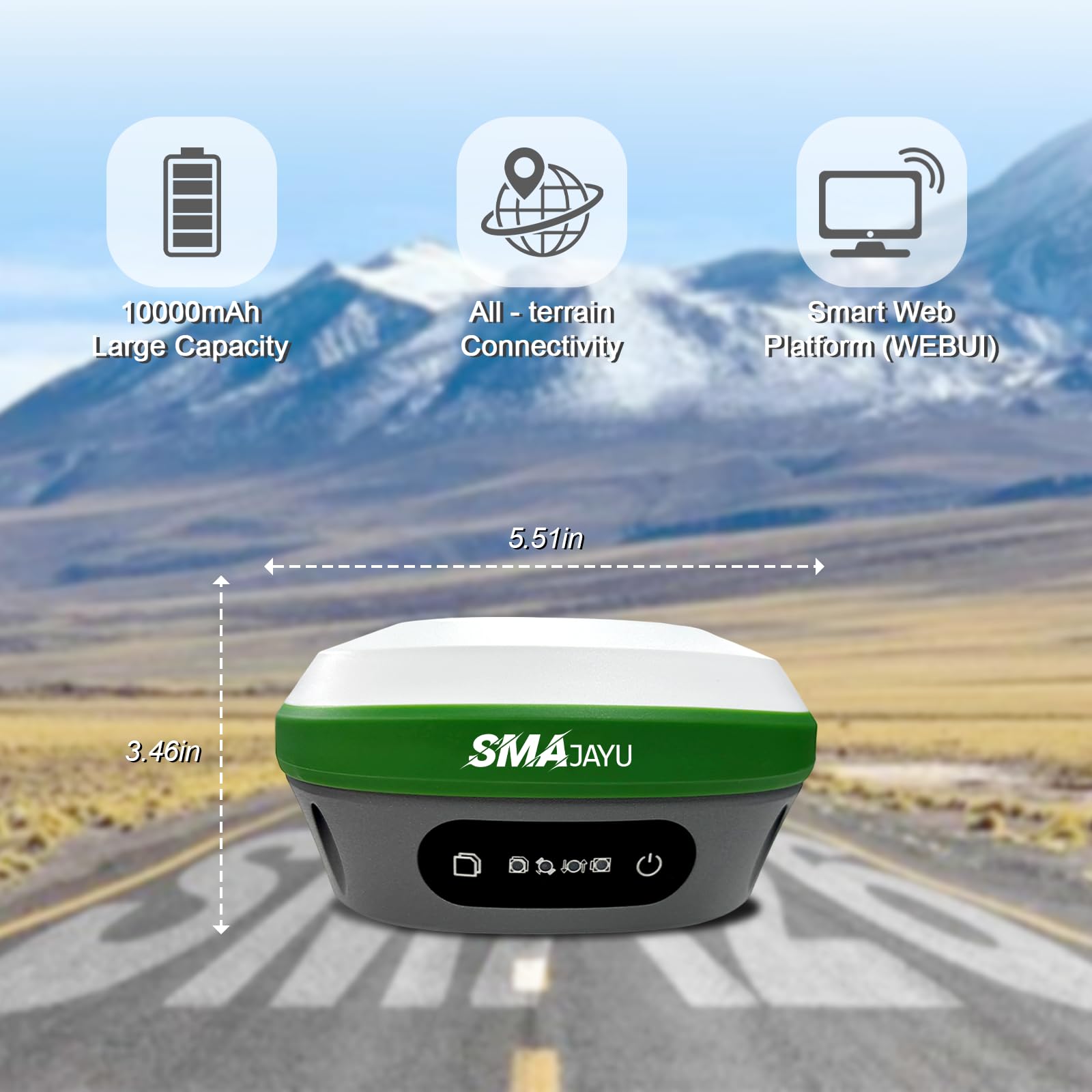
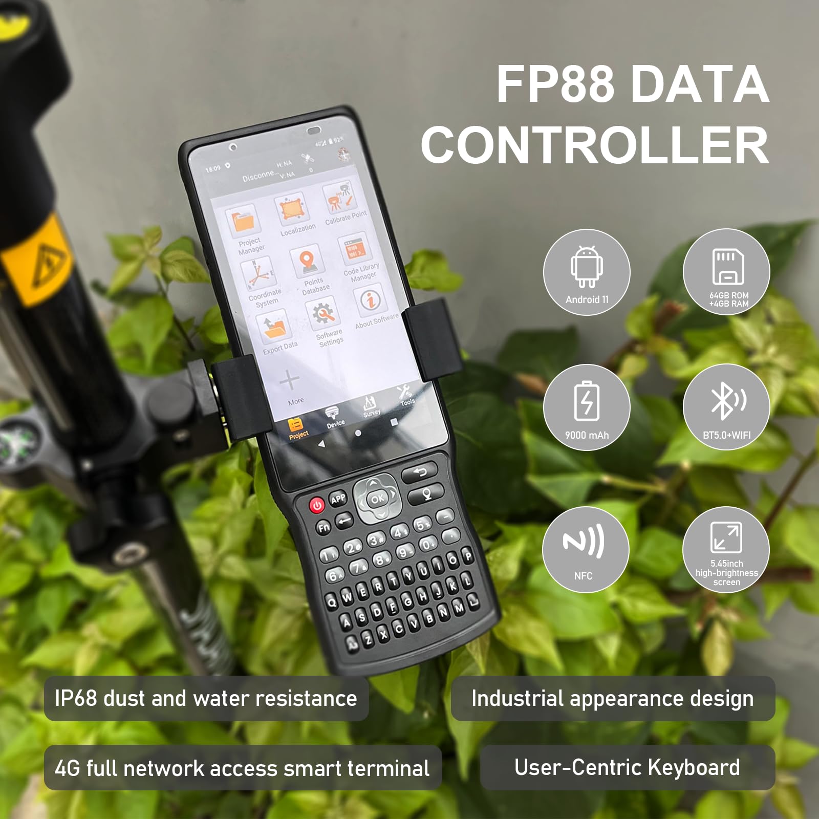
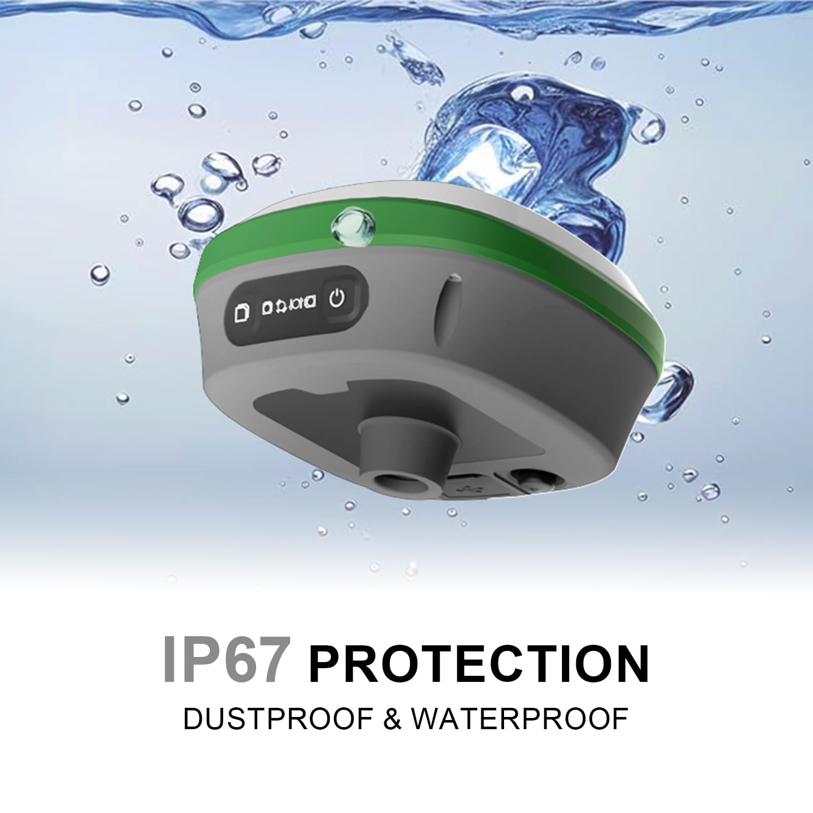
The SMA26 Plus GNSS RTK Rover & Base is a cutting-edge surveying system delivering 1cm accuracy with full-constellation satellite support and advanced tilt compensation. NOAA-certified and IP67-rated, it combines rugged durability with smart Android 11 handheld control, multi-protocol radio compatibility, and a powerhouse 20-hour battery life—ideal for civil engineering and topography professionals demanding precision and reliability in any terrain.


| ASIN | B0BYCR3VQQ |
| Additional Features | Bluetooth, Touchscreen, Waterproof |
| Are Batteries Included | Yes |
| Audio Output Mode | Digital |
| Battery Average Life | 2 days |
| Best Sellers Rank | #148,571 in Electronics ( See Top 100 in Electronics ) #159 in Handheld GPS Units |
| Brand | SMAJAYU |
| Built-In Media | 1*Handheld bracket,1*Handheld Charger, 1*Tape Measure,1*Extension Rod,1*Disc, 1*User Manual, 2*GNSS receiver,1*Handheld controller, 2*Power Adaper,2*Terminal Antenna |
| Compatible Devices | Smartphone |
| Compatible with Vehicle Type | Truck |
| Connectivity Protocol | Wi-Fi |
| Connectivity Technology | Radio and GNSS |
| Control Method | App |
| Customer Reviews | 4.6 out of 5 stars 22 Reviews |
| Display Type | LCD |
| Human-Interface Input | Buttons, Touchscreen |
| Item Dimensions L x W x H | 5.5"L x 5.5"W x 3.4"H |
| Item Weight | 9 Kilograms |
| Manufacturer | SMAJAYU |
| Map Types | Worldwide |
| Memory Storage Capacity | 32 GB |
| Model Name | SMA26 Plus Rover+Base |
| Model Year | 2024 |
| Mounting Type | Handheld |
| Operating System | Android |
| Resolution | 1408 |
| Screen Size | 5.5 Inches |
| Special Feature | Bluetooth, Touchscreen, Waterproof |
| Sport Type | Static and Movable |
| Supported Satellite Navigation System | BeiDou, GLONASS, GPS, Galileo |
| Touch Screen Type | Capacitive |
| Vehicle Service Type | Truck |
| Warranty Description | 1 year |
S**Y
Money saver
This is a amazing, sophisticated piece of equipment. i purchased to find my property stakes spread all over 50 acres of trees. Like a needle in a haystack. They have the best support i ever come across. I knew nothing of how to work this equipment but i feel their support turned me into a professional. I found all my stakes and saved over 100,000$ Our local land survey charge 5,000$ an acre on open land more with trees. I highly recommend this to anyone, well worth the money, Thank you SMAJAYU
D**K
Easy to use and the price is right!
We purchased this to be used in place of, or in supplement to, a total station for survey and mapping on an archaeological project. We had been hearing from colleagues for a few years now on the merits of a dGPS in an archaeological setting and this year we felt it was time to jump on the bandwagon. This product did not disappoint. First, I will admit that what drew our attention first and foremost is the price. The fact that we could purchase not one, but two units (one to serve as a base and the other as a rover) for less than $3K, which is what we would be paying for one decent used total station, was mind-blowing. Reading the reviews gave us pretty good confidence in the product, so we pulled the trigger. The reason why we're writing this review is, however, not because of how little it cost, but how well it performed in the field. It took literally minutes to figure out the settings, thanks to little details like voice notification from the units themselves, clarity of the UI of their software (SMA Survey), and some helpful videos on YouTube. As with any new ecosystem, it takes a while to figure out what's going on (it took a little while for us to work out how stakeouts work), but once there, everything became a breeze. We were collecting topo data at the speed of walking, literally. Tilt compensation is a game changer for mapping. We even tried laying out units (which we traditionally have used the total station for), which may not be quite as accurate as a TS but the time-savings may very well offset it. What perhaps may be of most value, however, is their support. Since we were slightly anxious about taking into the field not only a newly purchased product, but a new-to-us set of instruments, I contacted their support and they immediately set up a WhatsApp support thread with us so that we could make inquiries and usually get responses within 24 hours. Their dedication to making their products easy to use in device design, UI design, and support structure is, perhaps, the real winner here. Can definitely recommend.
R**A
Great product.
Great instruments. I wanted to change from the conventional known brands without losing the level of accuracy and reliability I have always had. I found SMAJAYO GPS and I tested it against others. Excellent tool. I was able to easily match everything while using a fairly simple software that came pre installed in the android data colector. I am thinking about getting 2 more sets. I recommend.
J**Y
Expanding with Confidence: GNSS Solutions That Work
I have been using custom base rover setups for a while and recently our company expanded and it has become nessasary to look into a plug and play setup. the sma26 is a very accurate stable and easy to use product which has given us the sub-centimeter data we need. i did have to send the sma26 back simply because it uses a newer radio frequency. We have many grade control systems that utilize trimtalk for rtcm corrections. I would like to point out that the v1 that has trimtalk works seemlessly with the existing trimble machines and hase saved us thousands a year as the smajayu devices allow full constellations without have to pay a service fee
J**I
Overall Pleased
Extremely pleased with the product and quality. After a few projects use everything seems to be well made and easy to use. I even reached out to customer service with a question and received a prompt response. Will be ordering again from seller
T**S
Precisión y calidad a buen precio.
Excelente producto, posee una excelente precisión de hasta menos de 1 cm en escenarios óptimos. Las herramientas que se pueden encontrar en la aplicación son muy útiles y prácticas para hacer revisiones rápidas como cálculo de áreas pero con la ventaja de poder generar capas CAD lo que lo hace super intuitivo. Permite conectarse a diferentes mapas satelitales mediante conexión wifi o mediante tarjeta SIM. Se pueden observar los levantamientos en vistas 3D lo que permite rápidamente observar las depresiones de un terreno sin la necesidad de usar la pc. Posee buena recepción aún en terrenos relativamente quebrados. Los tutoriales en línea son muy útiles para reconocer los pasos esenciales para iniciar a trabajar con el equipo. Lo recomiendo.
M**R
Difficult to learn how to use it.
The device arrived in good condition, but I could not operate it. The sales people in China were nice and tried to help to no avail. The tech support in China sent me worthless videos that advertised their product instead of showing how to use it. The instruction manual was not good. The Utube instruction videos were way too fast. I got some assistance from CoPilot but still could not figure it out. I recognize that due to my advanced age (81) it is difficult for me to learn new things. Luckily I got it from Amazon and can get a full refund. Mike, Registered Land Surveyor.
A**J
Value for money
I got this last month for my survey business. The product works as expected and is definitely worth the amount you spend. The customer service is also excellent as they helped a lot with all the connectivity related questions I had.
Trustpilot
1 month ago
4 days ago