
DOWNLOAD THE APP


Customer Services
Copyright © 2025 Desertcart Holdings Limited
DOWNLOAD THE APP
📍 Survey Smarter, Not Harder — Precision Meets Power in Your Palm
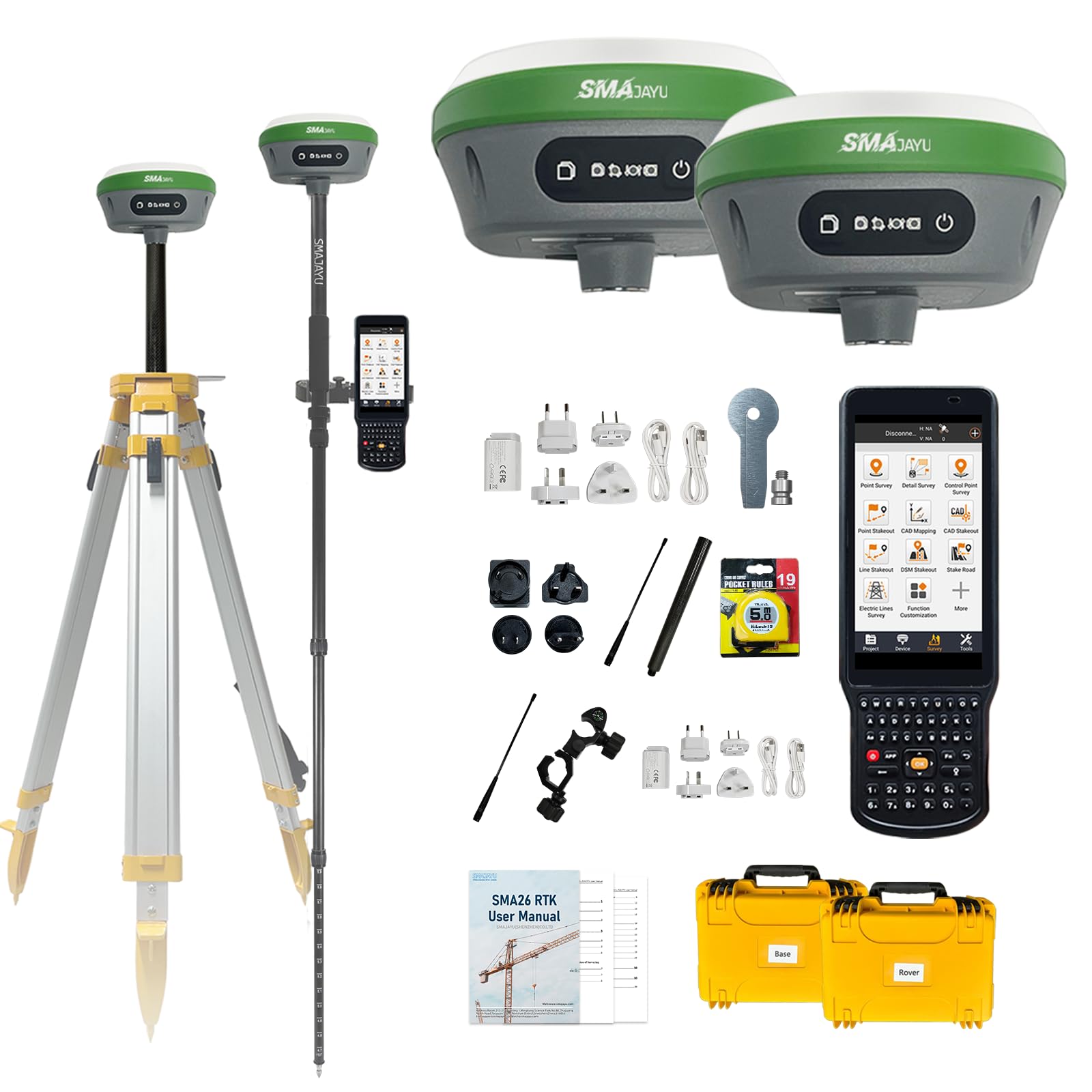
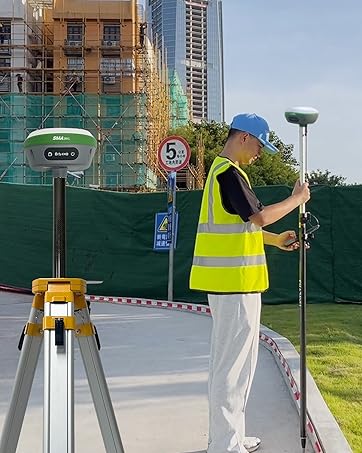
The SMA26 GNSS IMU RTK GPS Surveying System is a NOAA-certified, dual-receiver solution delivering centimeter-level accuracy with 1408 satellite channels. Featuring a 5km radio range via CSS (Lora) protocol, integrated inertial navigation, and a handheld collector with pre-installed, updateable software, it’s engineered for professional-grade construction, geodetic, and engineering surveys. Compact, power-efficient, and ready to handle complex fieldwork with seamless connectivity and reliable performance.


| ASIN | B0BQ6WB3R4 |
| Best Sellers Rank | 5,520 in GPS Navigation Accessories |
| Department | mens |
| Guaranteed software updates until | unknown |
| Item model number | SMA26 |
| Language | English |
| Manufacturer | SMAJAYU |
| Product Dimensions | 13.97 x 13.97 x 8.64 cm; 9 kg |
K**R
Great kit, shame about the support
It would have 5 but customer services / tech support hasn't responded to 2 email with. Impressed with kit out of the box and great value. But disappointed that the support hasn't replied to email with a support querry
E**Z
I'd like to start by saying though I've used and tested various brands of GPS equipment. I purchased this one and immediately was not disappointed. After about a month of tests, I've found this product to be reliable and consistently accurate. The GPS receivers will definitely run for more than a day with just one charge. The USB-C charging cables provided are great, especially compared to working with other major brands that require a special charging base for charging the batteries. As a test I went almost 5 miles away from my base and still had reception. The IMU is accurate as well. The data collector and software has been great as well. The software is pre-installed and runs pretty smooth. It allows you to plug in a SIM card for those that enjoy using NTRIP services for their surveys. Long story short, the unit and software is a great value for your money. Their customer service is amazing. Just send them an email and they will respond in under 24 hours with the correct and detailed information. I don't normally write reviews for anything, but this equipment is definitely worth purchasing and trying out, because you will not be disappointed.
D**.
The learning curve on this was long, but it works like advertised. There are cons - no instruction manual; the data collector screen is difficult to see in bright sunlight; the available YouTube videos are not all that helpful - but the pros outweigh them. The units work well and provide real-time centimeter accuracy. The range is advertised as up to 1km, and I realize that is in the best of circumstances, but we are having no problem up to one mile in the hills and heavy foliage of the Ozarks. I suspect we can get even better range. The couple of times I have contacted the sellers, they have responded quickly. This is a good product at a fantastic price.
F**Z
I had to return this equipment due to a significant discrepancy in elevation measurements, showing a vertical difference of approximately 100 feet. Although the technical support team has been in contact with me, their response was that I need at least 3 known points to obtain an accurate elevation. However, if that’s the case, I don’t see the advantage of using GPS, as I could achieve the same result with a total station, which would also be lighter since I would be using a prism on the pole instead of a rover. I have reviewed comments from other users who report similar issues, while some mention that the equipment has worked perfectly for them horizontal and vertical. This leads me to believe that the unit I received might have some defect or configuration issue. He tenido que devolver este equipo debido a una discrepancia significativa en las mediciones de elevación, mostrando una diferencia vertical de aproximadamente 100 pies. Aunque el soporte técnico ha estado en contacto conmigo, su respuesta fue que necesito tener al menos 3 puntos conocidos para obtener una elevación exacta. Sin embargo, si ese es el caso, no veo la ventaja de utilizar un GPS, ya que podría lograr el mismo resultado con una estación total, que además sería más ligera, ya que en la vara no llevaría un rover, sino un prisma. He revisado comentarios de otros usuarios que reportan problemas similares, mientras que algunos mencionan que el equipo les ha funcionado perfectamente. Esto me hace pensar que la unidad que recibí podría tener algún defecto de fabricación o configuración.
P**E
Very good Gnss receiver. It gets fix very fast at startup and it has a very rugged case. I got to compare obtained data between coordinates obtained with other different popular brands and they were perfect. Less than a CM difference. The software is user friendly and has a lot of good functions in it. The support team are great and they reply almost immediately. Have had a great experience so far.
G**Z
Traducir texto con la cámara Excellent product, I have been able to complete planimetric and altimetric work in better times than a total station. Its centimeter accuracy with the checkpoint survey option is really good. This is my second purchase in version 2 and I have no complaints. good product quality price.
Trustpilot
2 weeks ago
2 months ago